the Creative Commons Attribution 4.0 License.
the Creative Commons Attribution 4.0 License.
 | 16 Oct 2019
Centennial-scale precipitation anomalies in the southern Altiplano (18° S) suggest an extratropical driver for the South American summer monsoon during the late Holocene
Ignacio A. Jara
Antonio Maldonado
Leticia González
Armand Hernández
Alberto Sáez
Santiago Giralt
Roberto Bao
Blas Valero-Garcés
Modern precipitation anomalies in the Altiplano, South America, are closely linked to the strength of the South American summer monsoon (SASM), which is influenced by large-scale climate features sourced in the tropics such as the Intertropical Convergence Zone (ITCZ) and El Niño–Southern Oscillation (ENSO). However, the timing, direction, and spatial extent of precipitation changes prior to the instrumental period are still largely unknown, preventing a better understanding of the long-term drivers of the SASM and their effects over the Altiplano. Here we present a detailed pollen reconstruction from a sedimentary sequence covering the period between 4500 and 1000 cal yr BP in Lago Chungará (18∘ S; 4570 m a.s.l.), a high-elevation lake on the southwestern margin of the Altiplano where precipitation is delivered almost exclusively during the mature phase of the SASM over the austral summer. We distinguish three well-defined centennial-scale anomalies, with dry conditions between 4100–3300 and 1600–1000 cal yr BP and a conspicuous humid interval between 2400 and 1600 cal yr BP, which resulted from the weakening and strengthening of the SASM, respectively. Comparisons with other climate reconstructions from the Altiplano, the Atacama Desert, the tropical Andes, and the southwestern Atlantic coast reveal that – unlike modern climatological controls – past precipitation anomalies at Lago Chungará were largely decoupled from north–south shifts in the ITCZ and ENSO. A regionally coherent pattern of centennial-scale SASM variations and a significant latitudinal gradient in precipitation responses suggest the contribution of an extratropical moisture source for the SASM, with significant effects on precipitation variability in the southern Altiplano.
- Article
(8838 KB) - Full-text XML
-
Supplement
(553 KB) - BibTeX
- EndNote


Detailed paleoclimate records are not only necessary to document past climate anomalies, but also to decipher regional drivers of atmospheric variability and explore teleconnections that extend beyond the period of instrumental climate measurements (Wanner et al., 2008; Loisel et al., 2017). Unfortunately, the number of reliable climate reconstructions is still small in many regions of the world, which hinders a contextualization of modern climate trends into longer-term natural variability. This long-term perspective becomes critical considering the brief period of meteorological measurements, the current scenario of unprecedented climate change, and the uncertainties about future trends (Deser et al., 2012; Neukom et al., 2015).
In the tropical Andes (5–13∘ S) and the Altiplano (13–22∘ S) regions of South America, a set of well-grounded paleoclimate reconstructions have revealed that significant precipitation changes occurred during the most recent millennia (Seltzer et al., 2000; Baker et al., 2005; Giralt et al., 2008; Bird et al., 2011a; Novello et al., 2016), reflecting decadal, centennial, and millennial changes in the mean strength of the South American summer monsoon (SASM). In addition, a composite tree ring chronology from the Altiplano showed that decadal anomalies in SASM-derived precipitation have been strongly modulated by the variability of the El Niño–Southern Oscillation (ENSO) over the last 700 years (Morales et al., 2012). This control is consistent with instrumental measurements which show a significant relationship between modern ENSO variability and summer precipitation at inter-annual timescales (Vuille et al., 2000; Knüsel et al., 2005; Garreaud, 2009). However, it is still unknown if this close relationship extends at timescales longer than decadal. Evidence from precipitation records covering the last 2 millennia in the Altiplano is at odds with the modern ENSO–precipitation relationship (Vuille et al., 2012), suggesting that the instrumental relationship has not remained stationary in time. These discrepancies have prompted discussions regarding the existence of different drivers of past SASM-derived precipitation in the Altiplano, such as the austral summer insolation (Bustamante et al., 2016), Northern Hemisphere temperatures (Vuille et al., 2012), the latitude of the Intertropical Convergence Zone (ITCZ) (Bird et al., 2011a, b), solar variability (Novello et al., 2016), and moisture levels in the extratropical Atlantic region (Baker et al., 2005; Apaéstegui et al., 2018).
Here we present a new pollen-based precipitation record for the Altiplano that covers the interval between 4500 and 1000 cal yr BP. The timing and direction of precipitation anomalies inferred from the pollen data are evaluated with the primary aim of exploring past drivers of precipitation change and assessing the evolution of teleconnections between the Altiplano, other regions in South America, and the Pacific and the Atlantic oceans. Our pollen data were therefore compared with proxy-based records from the Altiplano and the tropical Andes, along with reconstructions of past ITCZ variability and ENSO-like changes.
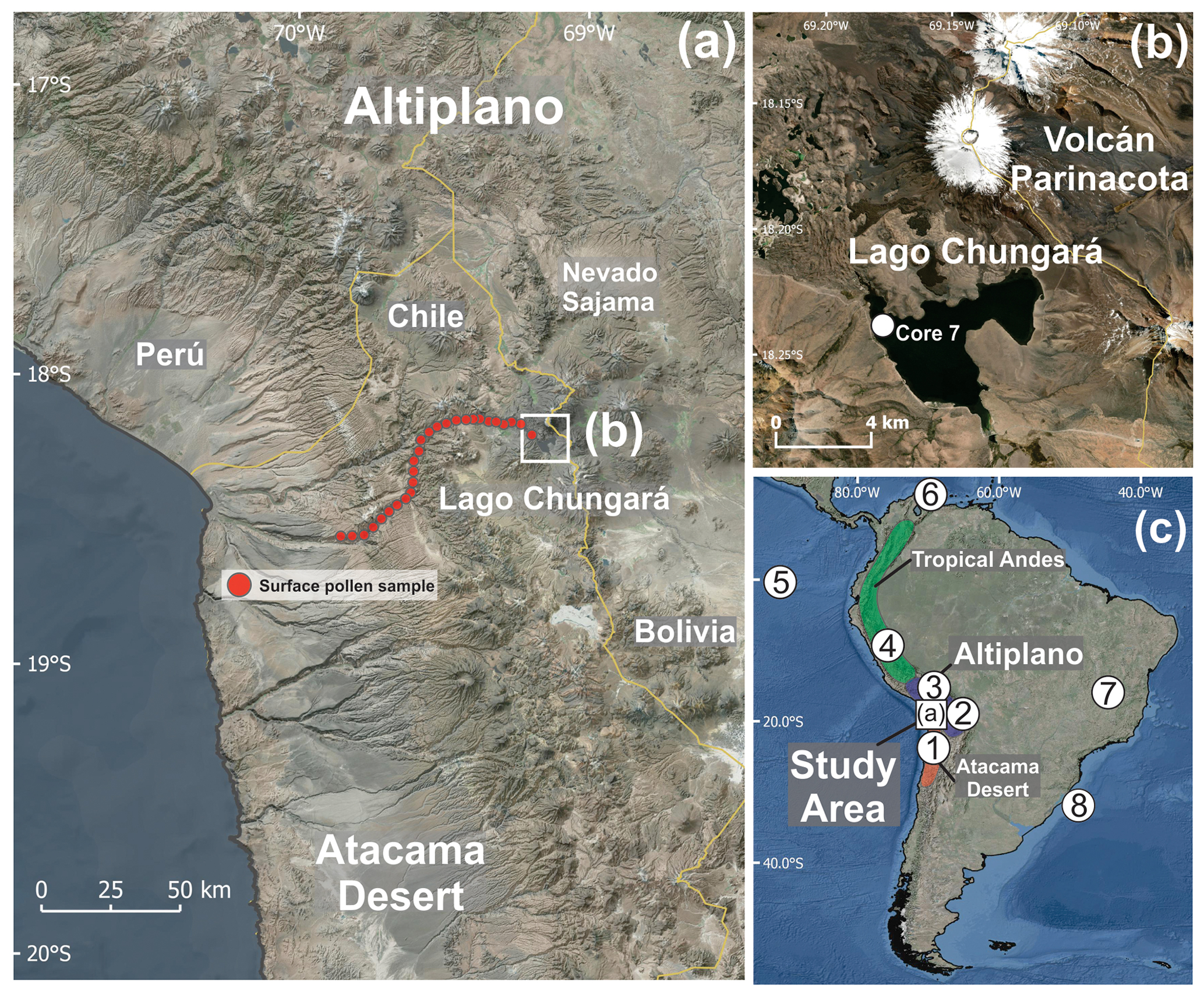
Figure 1Physiography aspects of the study area. (a) Digital elevation model (DEM) of the southern Altiplano and the southern Atacama Desert depicting the position of Lago Chungará, the surface pollen transect, and the Nevado Sajama. (b) Satellite image of Lago Chungará and Volcán Parinacota showing the position of core 7. (c) South America map with the location of climate reconstructions mentioned in the text: (1) Quebrada Maní and Salar del Huasco, (2) Chiflonkhakha cave system, (3) Lago Titicaca, (4) Lago Junín and Laguna Pumacocha, (5) El Junco Crater Lake, (6) Cariaco Basin, (7) Lapa Grande Cave, (10) core GeoB6211-1/2.
2.1 The Altiplano
The Altiplano (13–22∘ S) is a high Andean tectonic plateau that covers an area of ∼190 000 km2 encompassing the central Andes Cordillera of southern Perú, western Bolivia, and northern Chile and Argentina (Fig. 1). Sitting in a north–south axis over Cenozoic ignimbrites and Cretaceous marine deposits, this high Andean plateau has widths ranging from 200 to 300 km and mean elevations between 3000 and 5000 m a.s.l. (De Silva, 1989; Garzione et al., 2006). Multiple phases of tectonic uplifting and crustal shortening during the last 30 Myr account for the unusual high elevations of this continental plateau (Isacks, 1988), although more recent investigations suggest a slow and steady uplift over the last 40 Myr (Barnes and Ehlers, 2009). In any case, it has been estimated that the present-day Altiplano altitude was attained around 6–5 Ma (Garzione et al., 2017). Since that time, continuous internal drainage and erosional processes have produced a general flattening of the elevated surface, resulting in several large-scale plane fluvio-lacustrine basins (Garzione et al., 2006). Although the Altiplano has been volcanically active since its initial formation, present magmatism is expressed exclusively at its western margin in the form of a prominent Cretaceous–Neogene magmatic arc featuring several 5000–6000 m a.s.l. stratovolcanoes (Allmendinger et al., 1997).
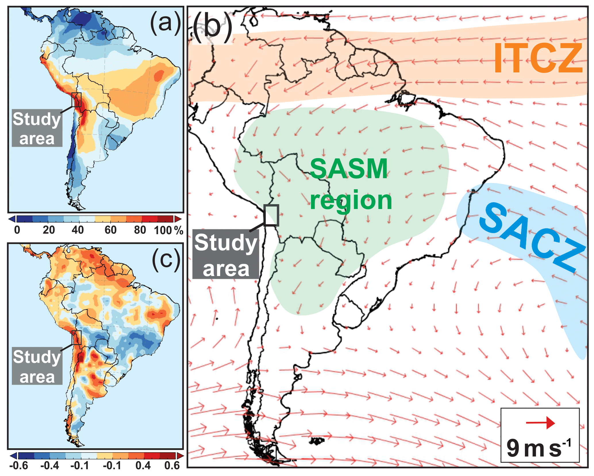
Figure 2South American atmospheric features based on reanalysis data. (a) Summer (DJFM) percentage of the total annual precipitation amount based on the ERA-40 reanalysis dataset (1980–2017), (b) mean summer (DJFM) wind fields (m s−1) at 850 hPa for the 1980–2017 period from the ERA-Interim reanalysis, and (c) correlation (1980–2017) between South America summer precipitation (DJFM) and the Southern Oscillation Index (SOI) during the austral summer (DJFM). All precipitation data correspond to the ERA-40 reanalysis dataset, which is freely provided by the European Centre for Medium-Range Weather Forecasts (ECMWF). The SOI is freely provided by the National Oceanic and Atmospheric Administration (NOAA), USA. ITCZ: Intertropical Convergence Zone, SACZ: South Atlantic Convergence Zone, SASM: South American summer monsoon.
The climate of the Altiplano is cold and semiarid with mean annual temperatures and precipitation ranging from 4 to 17 ∘C and 20 to 800 mm, respectively. The pronounced climate gradients observed at stations across this region result from its large latitudinal extension, including subtropical and extratropical regions, as well as altitudinal differences between the central plateau and its eastern and western flanks. Summer (DJFM) precipitation, both as rain and snow, represents around 60 %–90 % of the total annual amount (Fig. 2a) and comes in the form of convective storms associated with the development of the SASM in the interior of the continent (Garreaud et al., 2003) (Fig. 2b). Seasonal and inter-annual precipitation variability in the Altiplano is directly associated with the strength of the SASM, which is in turn controlled by both the latitudinal position of the ITCZ at the lower atmospheric level (>850 hPa) and the Bolivian high-pressure cell at the upper level (<300 hPa; Garreaud et al., 2003). In general, above-mean summer precipitation is associated with a southward extension of the ITCZ and a southward position of the Bolivian high-pressure cell, which results in an easterly wind anomaly and a strengthening of the SASM (Vuille, 1999; Aceituno and Montecinos, 1993; Garreaud et al., 2009). Easterly SASM moisture comes in two distinctive modes: a northerly mode originating in the Amazon basin and a southerly mode sourced in the Gran Chaco basin and the South Atlantic Ocean (Chaves and Nobre, 2004; Vuille and Keimig, 2004). In addition, there is a general consensus that a significant amount of inter-annual variability in summer precipitation over the Altiplano is influenced by the El Niño–Southern Oscillation (Garreaud and Aceituno, 2001; Garreaud et al., 2003; Vuille et al., 2000; Sulca et al., 2018). During la Niña phases, the Bolivian high-pressure cell sits over the Altiplano, weakening the prevailing westerly flow and promoting the incursion of convective storms associated with the SASM. As a result, above-mean precipitation occurs more often during La Niña years, whereas opposite anomalies tend to occur during El Niño phases (Fig. 2c).
The vegetation of the Altiplano is rich and diverse, presenting a great number of different shrubland, grassland, peatland, and forest communities. The distribution of these communities varies locally according to elevation, soil, erosion, water availability, and drainage; it varies regionally by the gradients in precipitation and temperature described above (Brush, 1982). For the sake of the pollen–climate interpretations of this study and considering the outstanding diversity of the Altiplano vegetation, we restricted our characterization to the vegetation belts established across the western Andean slopes and the southern Altiplano around our study site. Our brief and simplified description of the regional vegetation communities is based on the much more comprehensive work of Villagrán et al. (1983), Arroyo et al. (1988), Rundel and Palma (2000), and Orellana et al. (2013). We followed the taxonomic nomenclature adopted by Rodrıguez et al. (2018).
The prepuna vegetation belt established above the upper margin of the absolute desert from ∼2000 to 3200 m a.s.l., and it is a low-density vegetation community (coverage >40 %) composed of a floristically diverse assemble of shrubs and herbs. It is dominated by shrubs such as Ambrosia artemisioides (Asteraceae), Atriplex imbricata (Chenopodiaceae), and Aloysia deserticola (Verbenaceae), with several herbs such as Descurainia pimpinellifolia (Brassicaceae), Balbisia microphylla (Francoaceae), and Bryantiella glutinosa (Polemoniaceae), as well as scattered cacti such as Browningia candelaris and Corryocactus brevistylus.
The puna belt sits above the aforementioned formation, roughly between 3000 and 4000 m a.s.l. It is a floristically more diverse and more densely vegetated shrubland–grassland community. The puna belt is dominated by Fabiana densa (Solanaceae), Baccharis boliviensis (Asteraceae), Diplostephium meyenii (Asteraceae), Lophopappus tarapacanus (Asteraceae), and Ephedra americana (Ephedraceae). Other plants natural to the puna belt are annual herbs such as Chersodoma jodopappa (Asteraceae), Junellia seriphioides (Verbenaceae), the cactus Cumulopuntia echinacea, and the fern Cheilanthes pruinata (Pteridaceae). Grasses representative of the Poaceae family are Nassella pubiflora and Eragrostis kuschelii.
A gradual transition from a shrubland- to a grassland-dominated community occurs at the upper limit of the puna belt. Above 4000 m a.s.l., high Andean steppe tends to replace puna scrubs, forming a grassland belt characterized by several species of the Poaceae family such as Festuca arundinacea, F. chrysophylla, Deyeuxia breviaristata, and Poa lepidula and several species of the Anatherostipa genus. This high-elevation steppe also features scattered shrubs such as Parastrephia lucida and P. quadrangularis (Asteraceae). Woodlands of the tree Polylepis tarapacana (Rosaceae) occur preferably on the north-facing slopes at elevations above 4100 m a.s.l., usually accompanied by species such as Azorella compacta (Apiaceae), Parastrephia teretiuscula (Asteraceae), and Baccharis tola (Asteraceae). The altitudinal limit of vegetation, which sometimes exceeds 5000 m a.s.l. (Orellana et al., 2013), is occupied by a low shrubland community mostly made up of cushion plants such as Pycnophyllum molle (Caryophyllaceae), the cactus Cumulopuntia ignescens, and several species of the genera Werneria (Asteraceae) and Nototriche (Malvaceae), with this latter plant genus usually found on the characteristic rocky substrates of the mountain slopes.
2.2 Lago Chungará
Lago Chungará (18.24∘ S, 69.15∘ W; 4570 m a.s.l.; 23 km2; 40 m maximum depth) is located at the base of Volcán Parinacota on the western border of the southern Altiplano plateau (Fig. 1). The lake sits over Miocene and Pleistocene alluvial, fluvial, lacustrine, and volcanic sediments of the Lauca Basin (Gaupp et al., 1999). To the west, the western Andean flanks connect the basin with the lowlands of the Atacama Desert through a series of river basins and dried canyons (Fig. 1a). Lago Chungará was formed by the damming of the Lauca River caused by a debris avalanche during a partial collapse of the ancient Volcán Parinacota caldera, previously dated between 17 000 and 15 000 cal yr BP (Hora et al., 2007). A recent study using 10Be surface exposure dates indicates that the collapse of the old cone of Volcán Parinacota led to a major lake expansion at about 8800 cal yr BP (Jicha et al., 2015). The main inlet of the lake is the Río Lauca to the south and the ephemeral streams Ajata and Sopocalane to the west. Lago Chungará has no surface outlets, although groundwater outflow has been reported (Herrera et al., 2006). The absence of lacustrine deposits above the lake suggests that its present-day water levels are the highest in their history (Herrera et al., 2006). The Lago Chungará area receives between 50 and 670 mm of precipitation annually (the mean for 1961–2016 is 353 mm), with 88 % of this the total amount being received during summer months (DJFM). Mean annual temperature is 4.5 ∘C. The precipitation at the Lago Chungará heavily contrasts with the Andean slopes and the lowlands of the Atacama Desert to the west, where precipitation plummets to zero below 2500 m a.s.l. The close link between ENSO and summer rainfall in the Altiplano mentioned above is clearly seen at Lago Chungará, where instrumental time series show that around 35 %–40 % of summer rainfall variability (1961–2016) results from variations in the tropical Pacific climatological state, with significant correlation between instrumental rainfall and ENSO (El Niño 3.4 index; Pearson correlation coefficient ; p value <0.01). The vegetation around the lake is dominated by high Andean tussock grasses with scattered Polylepis woodland.
2.3 Previous investigations in Lago Chungará
Lago Chungará has been the focus of several paleolimnological and paleoclimatological studies over the last 20 years. An initial detailed seismic profile of the sediments was presented by Valero-Garcés et al. (2000). A 500-year reconstruction of hydrological variability around Lago Chungará was developed 3 years later based on sedimentological, geochemical, and stable isotope analyses from a 57 cm long sediment core (Valero-Garcés et al., 2003). In 2002, a field campaign retrieved 15 new sediment cores from different areas of the lake, and several publications have emerged from the analysis of those sediment sequences. Such studies include the following: a detailed lithological correlation of all cores (Sáez et al., 2007); an analysis of the physical properties of the sediments such as magnetic susceptibility, mineral composition, total organic carbon, and grey colour values (Moreno et al., 2007); a climate reconstruction based on the statistical analysis of mineralogical and chemical parameters (total organic carbon, an X-ray fluorescence (XRF) scanner, grey colour values, and total biogenic silica among others) and a detailed chronological framework (Giralt et al., 2008); the oxygen and carbon isotope composition of diatom silica and their relationship with the hydrological evolution of the lake, as well as solar and ENSO forcings (Hernandez et al., 2008, 2010, 2011, 2013); and the petrology and isotopic composition of the carbonate fraction (Pueyo et al., 2011). More recently, Bao et al. (2015) presented a long-term productivity reconstruction based on fossil diatom composition and geochemical data, assessing the interplay between regional precipitation, lake levels, and organic activity in Lago Chungará. Overall, these studies have provided a detailed paleolimnological and paleoenvironmental history of Lago Chungará that extends for at least 12 800 years, showing a sedimentation regime marked by diatom-rich deposits interbedded with multiple tephra and carbonate-rich layers (Pueyo et al., 2011). Volcanic input, more frequently recorded after 7800 cal yr BP, was most likely composed of tephra deposits erupted from Volcán Parinacota (Sáez et al., 2007). Relatively high lake levels are recorded before 10 000 cal yr BP, in overall agreement with a pluvial interval documented elsewhere in the Altiplano (Giralt et al., 2008). Dry conditions seem to have prevailed between 8000 and 3500 cal yr BP (Pueyo et al., 2011), with peak aridity probably occurring between 8000 and 6000 cal yr BP (Moreno et al., 2007; Giralt et al., 2008; Pueyo et al., 2011). Relatively high lake levels prevailed over the last 5000 years (Sáez et al., 2007), superimposed on several high-amplitude lake stand oscillations after 4000 cal yr BP (Sáez et al., 2007; Giralt et al., 2008). Humid and high lake stands have been recognized between 12 400–10 000 and 9600–7400 cal yr BP, while dry intervals prevailed between 10 000–9600 and 7400–3500 cal yr BP (Bao et al., 2015). The last 200 years are marked by overall dry conditions (Valero-Garcés et al., 2003). Despite all this information, the hydrological history around Lago Chungará and its regional drivers over the most recent millennia has not yet been addressed in detail (Hernández et al., 2010; Bao et al., 2015).
In November 2002, 15 sediment cores up to 8 m long were obtained from different parts of the lake using a raft equipped with a Kullenberg corer (Sáez et al., 2007). The fossil pollen sequence presented here was developed from core 7, which was obtained from the northwestern border of the lake at 18 m of water depth (Sáez et al., 2007; Fig. 1b). In addition, we obtained pollen data from 26 surface samples collected along a west–east transect on the western Andes slope at 18∘ S with the aim of determining the pollen signals associated with modern vegetation belts. Surface pollen samples were obtained from exposed soils located at regular intervals of ∼100 m, from 2100 to 4400 m a.s.l. Thus, a surface pollen transect was formed crossing all vegetation belts established across the western Andean slopes up to the base of Lago Chungará (Fig. 1a). Furthermore, we obtained annual temperature and summer precipitation data for each surface sample point from the WorldClim2 dataset (Fick and Hijmans, 2017), with the aim of documenting the climate gradients associated with the pollen transect. All surface pollen and climate data were used to complement our paleoclimate inferences.
The 26 surface samples plus 49 fossil pollen samples from core 7 were prepared following standard procedures for palynological analysis (Faegri and Iversen, 1989) in the Laboratory of Paleoecology and Paleoclimatology of CEAZA, La Serena, Chile. Pollen data are expressed as a relative percentage, which was calculated from the sum of a minimum of 300 terrestrial pollen grains. The percentage of aquatic pollen was calculated from a sum that included all terrestrial and aquatic pollen. Pollen accumulation rate (PAR; particles yr−1 cm−2) was calculated for terrestrial and aquatic pollen using data from the age–depth model published by Giralt et al. (2008). The statistical analysis of pollen data included a stratigraphically constrained cluster analysis (CONISS) for the identification of major pollen changes carried out with the software Tilia (Grimm, 1987).
4.1 Stratigraphy and chronology
Core 7 comprises sections 7A-1K-1 (146 cm), 7A-2K-1 (151 cm), and 7A-3K-1 (51 cm) with a total length of 348 cm. These core sections correspond to Subunit 2b described in Sáez et al. (2007), composed of dark grey diatomite with abundant macrophyte and four black tephra layers. These layers are made of andesitic and rhyolitic material with the presence of amphibole (Moreno et al., 2007). The chronological framework used in this study is based on the one presented in Giralt et al. (2008). The chronology of core 7 is constrained by three AMS radiocarbon dates obtained from Subunit 2b in cores 11 and 14, which were translated into core 7 after direct correlation based on seismic profiles and tephra keybeds identified as peaks in magnetic susceptibility (Sáez et al., 2007). This chronology uses a modern reservoir effect of 14C at 3260 years, which is assumed to be constant throughout the whole Subunit 2b (Supplement). A constant reservoir effect for this unit is supported by multiple lines of evidence and suggests that the average characteristics of the lake – such as water depth and volume – did not change during the time represented by Subunit2b (Giralt et al., 2008). The chronological framework indicates that core 7 encompasses the period between 4500 and 1000 cal yr BP, with depositional rates ranging from 0.26 to 1.31 mm yr−1. Unfortunately, the last 1000 years of sediment history were not recovered during the field campaign (Supplement).
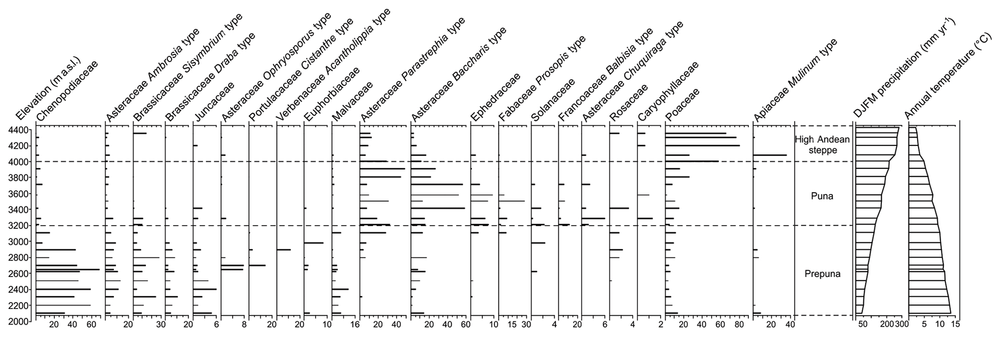
Figure 3Diagram with the altitudinal position of the 26 surface pollen assemblages collected along a west–east transect on the western Andes slope at 18∘ S. The elevation ranges of the main vegetation belts are shown along with the summer precipitation and annual temperature obtained using the WorldClim2 dataset (Fick and Hijmans, 2017).
4.2 Modern pollen transect
Our modern surface pollen transect reveals important changes in the abundance of pollen type across prepuna, puna, and high Andean steppe vegetation belts (Fig. 3). Between ∼2000 and 3200 m a.s.l. Prepuna pollen samples are largely dominated by Chenopodiaceae, Asteraceae (Ast.) Ambrosia type, Brassicaceae Sisymbrium type, B. Draba type, and Ast. Ophryosporus type. Other pollen types with minor abundances are Portulacaceae Cistanthe type, Juncaceae, and Malvaceae. Between ∼3200 and 4000 m a.s.l., puna dominant taxa include Ast. Parastrephia type and Ast. Baccharis type along with Ephedra spp., Fabaceae Prosopis type, Solanaceae, Ledocarpaceae Balbisia type, and Ast. Chuquiraga type. Above 4000 m a.s.l., surface pollen samples at the high Andean steppe are less diverse and overwhelmingly dominated by Poaceae with a minor contribution of Apiaceae Mulinum type. Mean annual temperatures associated with the transect show a sustained decrease from 14 ∘C at 2100 m a.s.l. to less than 3 ∘C at 4400 m a.s.l.; summer precipitation, on the other hand, exhibits a continuous increase from less than 40 mm yr−1 at 2100 m a.s.l. to more than 280 mm yr−1 at the upper limit of our transect.
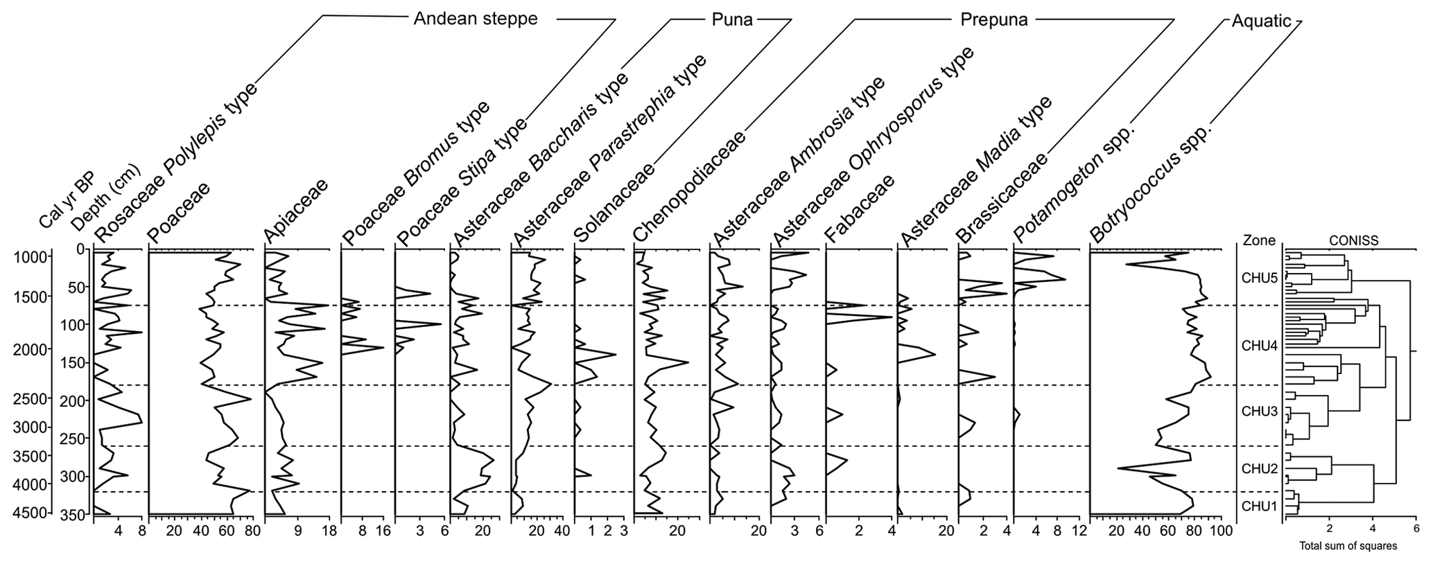
Figure 4Terrestrial and aquatic pollen percentages from core 7 in Lago Chungará. Pollen percentages are plotted against depth and age scales (Giralt et al., 2008). The diagram also shows the main zones of the records (right) determined with the aid of a CONISS cluster analysis.
4.3 Pollen record
Five general zones are recognized based on the major changes in pollen percentages (Fig. 4) and PAR (Fig. 5), assisted by a CONISS cluster analysis. Overall, the record is largely dominated by Poaceae (mean value 55 %), followed by Ast. Parastrephia type (13 %), Chenopodiaceae (8 %), Ast. Baccharis type (7 %), Apiaceae (6 %), Ast. Ambrosia type (4 %), and Polylepis spp. (3 %). The record-mean abundances of Botryococcus spp. and Potamogeton spp., the two most abundant aquatic taxa, correspond to 72 % and 2 % of the total terrestrial sum, respectively.
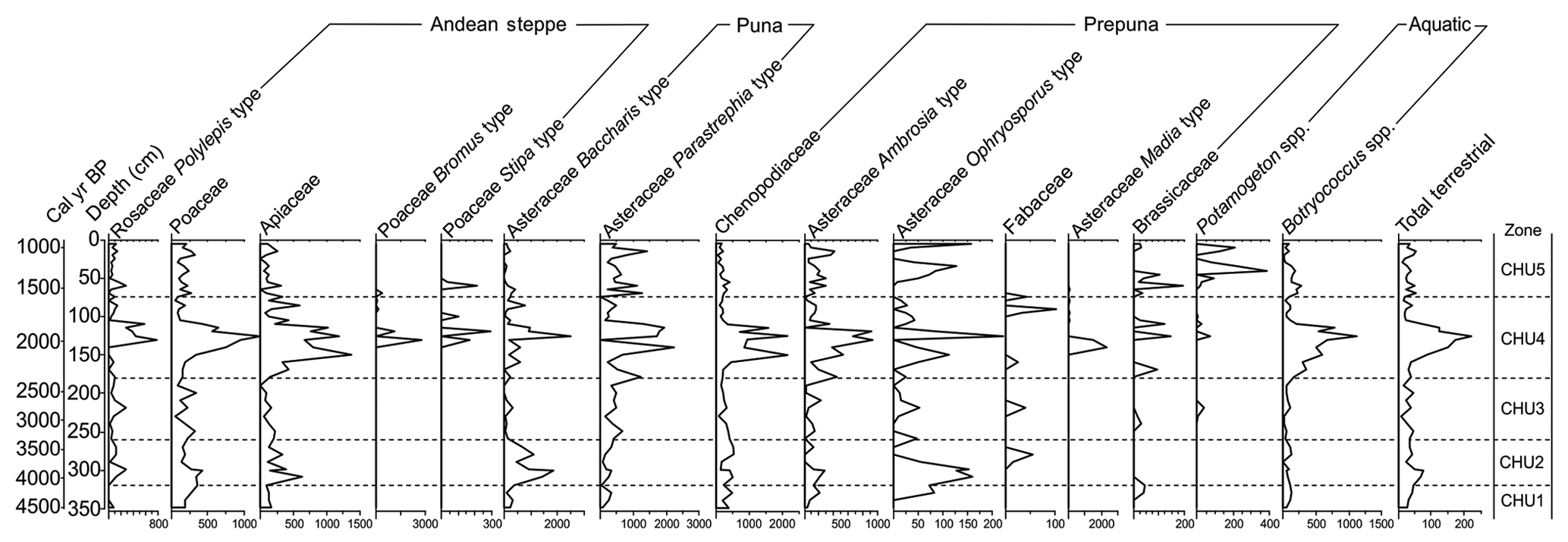
Figure 5Terrestrial and aquatic pollen accumulation rate (PAR; grain cm−2 yr−1) of the Lago Chungará sediment section. PAR values are calculated using the depositional time obtained from the age–depth model published by Giralt et al. (2008).
The basal portion of the record (Zone CHU1; 4500–4100 cal yr BP) features an above-mean percentage of Poaceae (67 %) and relatively low abundances of all other major taxa, especially Polylepis spp., which show a minimal presence in this zone (1 %). The PAR record indicates very low pollen accumulation overall for all taxa in this zone.
The following interval (Zone CHU2; 4100–3300 cal yr BP) exhibits a downturn of Poaceae (52 %), a rapid and sustained decline in Botryococcus spp. (56 %), and a significant increase in Ast. Baccharis type (19 %) and Ast. Ophryosporus type (2 %). These latter two increments are also displayed in the PAR diagram, which reveals otherwise relatively low values for all the remaining taxa.
Zone CHU3 (3300–2400 cal yr BP) is characterized by a recovery of Poaceae (59 %) and a notable decline in Ast. Baccharis type (3 %). Other significant changes in this zone include a rise in Polylepis spp. (4 %) and sustained increments of Ast. Parastrephia type (17 %) and Botryococcus spp. (67 %). The PAR diagram shows very low values of all terrestrial and aquatic taxa in this entire zone.
Zone CHU4 (2400–1600 cal yr BP) features below-mean abundances of Poaceae (49 %) and Ast. Parastrephia type (11 %) and marked increments of Apiaceae (9 %) and Botryococcus spp. (81 %). This zone also features the appearance of Poaceae Stipa type and P. Bromus type, along with minor peaks in Solanaceae and Fabaceae at the base and the top of this zone, respectively. The PAR diagram exhibits a notable increase in all terrestrial taxa and Botryococcus spp.
Finally, Zone CHU5 (1600–1000 cal yr BP) exhibits a sustained recovery of Poaceae (56 %), a rapid decline of Apiaceae (3 %), and a drastic drop of about 50 % in Botryococcus spp. (72 %) in the upper part of this zone. Other notable signatures of this zone are the minor presence of Brassicaceae, above-mean abundance of Ast. Ambrosia type (5 %), below-mean Ast. Baccharis type (3 %), and rapid increases in Ast. Ophryosporus type and the aquatic Potamogeton spp. (3 %). The PAR of all terrestrial taxa (except Brassicaceae) and Botryococcus spp. plummets to near-zero values, whereas Potamogeton spp. PAR shows noticeable increases.
5.1 Pollen–climate relationship
At present, Lago Chungará is situated within the high Andean steppe vegetation belt and, consistent with this position, pollen assemblages are primarily composed of high Andean pollen types. This composition suggests that high-elevation steppe vegetation dominated the surroundings of Lago Chungará between 4500 and 1000 cal yr BP. Nonetheless, the fossil pollen sequence shows a significant representation of pollen types belonging to vegetation belts situated at lower elevations on the western Andes slopes (i.e. prepuna and puna belts). For instance, high Andean pollen types (e.g. Polylepis spp., record mean 3 %) are occasionally presented in lower abundances than puna or prepuna elements (e.g. Chenopodiaceae, 8 %), although this might also be related to differences in specific pollen production and long-distance transport. A considerable altitudinal thermal gradient of up to 10 ∘C is observed in our surface transect, which corresponds to a lapse rate of −4.9 ∘C per 1000 m (Fig. 3), a value within the ranges calculated from the Andes of northern Chile and the Altiplano (e.g. Kull et al., 2002; Gonfiantini et al., 2001). Nevertheless, low-latitude (30 ∘ N to 30∘ S) Holocene temperature reconstructions estimate thermal oscillations of less than 0.8 ∘C in magnitude for the 4500–1000 cal yr BP period (Marcott et al., 2013). Climate–glacier models in the tropical Andes (16∘ S) provide a more regional constraint on past temperature variations, suggesting that temperatures during the Little Ice Age (∼600–100 cal yr BP) – arguably one of the coolest intervals in the Holocene – were between 2.2∘ and 1.1 ∘C cooler compared with modern conditions (Jomelli et al., 2011; Rabatel et al., 2008). Although the Chungará record did not cover the Little Ice Age, we consider those values as a benchmark for the potential magnitude of temperature variations during the time span of the Chungará record, which is clearly insufficient to explain the changes in vegetation observed in our reconstruction. Hence, we assume that precipitation is primarily responsible for the vegetation shifts recorded at Lago Chungará. Our surface pollen transect indicates a continuous increase in summer precipitation in the western Andean slopes from 2100 to 4400 m a.s.l. (Fig. 3), a trend that is well supported by the instrumental record and the published literature (Villagrán et al., 1981; Latorre et al., 2006). Based on this information, we infer above-mean abundances of high Andean taxa as humid conditions and above-mean abundances of puna and prepuna pollen as suggestive of dry periods (Latorre et al., 2006; Maldonado et al., 2005; De Porras et al., 2017). Canonical correspondence analysis (CCA) constrained to the climatic data from the WorldClim2 dataset (Fick and Hijmans, 2017) supports this pollen–climate relationship, showing a close and same-sign affinity between high Andean pollen types and precipitation in the two main CCA components (Fig. S2 in the Supplement). Terrestrial pollen accumulation reflects plant productivity and vegetation cover, two variables that increase from the prepuna to the high Andean steppe. Therefore, terrestrial PAR is used as a proxy for regional humidity. In other words, we interpret pollen variations at Lago Chungará as expansions and contractions of Andean vegetation belts and plant productivity in response to changes in summer precipitation. On the other hand, aquatic taxa exhibit notable variations at multiple parts of the sequence rather than a unique monotonic trend (Fig. 4). This mode of change suggests an underlying climate signal rather than prolonged changes in the lake surface area or water depth due to the continuous sediment infilling of the base (Hernandez et al., 2008; Bao et al., 2015). Thus, we interpret variations in aquatic taxa as changes in lake levels driven by regional precipitation (Jankovská and Komárek, 2000). More precisely, below-mean abundances of the freshwater algae Botryococcus spp. are interpreted as reduced water levels (Grosjean et al., 2001; Sáez et al., 2007), whereas above-mean abundances of macrophyte Potamogeton spp., which are currently present in shallow waters in the periphery of the lake (Mühlhauser et al., 1995), are interpreted as responding to centripetal expansions of palustral environments due to shallower lake levels (Graf, 1994). Finally, considering that 80 %–90 % of modern precipitation at the Lago Chungará area falls during summer months associated with the development of the SASM (Vuille, 1999; Fig. 2a), we interpret our precipitation changes as responding to long-term variations in the strength of the SASM.
5.2 Past precipitation trends
Relatively humid conditions are inferred prior to 4100 cal yr BP based on the dominance of Poaceae along with below-mean abundances of all puna and prepuna taxa. Above-mean abundances of Botryococcus spp. are coherent with this interpretation, suggesting relatively low variability in the water table and overall raised lake stands. Although Poaceae PAR values are relatively high, total terrestrial PAR is below the long-term mean during this interval, suggesting sparse vegetation cover. This early period of relatively high moisture and stable lake levels occurred during an interval of regional aridity and reduced water levels at Lago Chungará between 9000 and 4000 cal yr BP (Giralt et al., 2008; Bao et al., 2015), although studies have shown that this long interval was not homogenous, including significant wet–dry variability at sub-millennial timescales.
Between 4100 and 3300 cal yr BP, the record exhibits lower-than-mean Poaceae and Botryococcus spp. and above-mean Ast. Baccharis type and Ophryosporus type. Corresponding PAR increases reveal that the observed changes in the percentage diagram reflect genuine increments in the abundance of the aforementioned pollen types. Our modern pollen transect shows that comparable percentages of Ast. Baccharis type are found below 4000 m a.s.l., and therefore their expansion at Chungará points to a decrease in effective precipitation not lower than 60 mm yr−1 relative to modern values. This evidence and the very low terrestrial PAR observed during this zone suggest that the few puna and prepuna pollen grains deposited on the lake were most likely windblown from distant shrubland communities downslope. Consistent with a relatively dry climate, a drastic drop of Botryococcus spp. suggests an overall reduction in lake levels during this interval.
These changes are followed by a decline in Ast. Baccharis type by 3600 cal yr BP and a sustained expansion of Ast. Parastrephia type between 3400 and 2400 cal yr BP. They culminate with a period of persistent above-mean percentages of Apiaceae between 2400 and 1600 cal yr BP. The modern distribution of vegetation on the western Andes slopes and our modern pollen transect show that Apiaceae is one of the only families for which distribution occurred above 4000 m a.s.l. (Fig. 3). In fact, the species Azorella compacta is one of the dominant members above 4600 m a.s.l. in the altitudinal limit of vegetation in the Chungará area (Orellana et al., 2013). Additionally, the CCA shows a strong and positive association between Apiaceae and summer precipitation (Fig. S2). Hence, the rapid increase in Apiaceae between 2400 and 1600 cal yr BP likely represents a downward expansion of high Andean and subnival vegetation in response to a rise in precipitation. The PAR diagram shows a rapid expansion of representatives of all vegetation belts between 2400 and 1800 cal yr BP, expressed as an abrupt increment in the total terrestrial PAR (Fig. 5). These trends indicate a conspicuous increase in terrestrial plant productivity that was not restricted to the high Andean vegetation, as suggested by the percentage diagram, but rather to all vegetation belts downwards. Alternatively, the expansion of cold-tolerant Apiaceae species could have resulted from a cooling event. However, such a thermal excursion should have been associated with a decrease in plant productivity around the lake and downwards. Thus, the observed sequence of pollen changes is best explained by a significant increase in terrestrial plant coverage over the western Altiplano and adjacent Andes slopes, a response we attribute to a notable rise in regional precipitation between 2400 and 1600 cal yr BP. Consistent with this interpretation, both the percentage and PAR of Botryococcus spp. show above-mean values during this interval, suggesting persistent high lake stands. Similarly, diatom assemblages and geochemical data from Lago Chungará agree with these pollen–climate inferences, pointing to increasing moisture after 3500 cal yr BP (Bao et al., 2015; Giralt et al., 2008; Pueyo et al., 2011) and overall higher lake levels based on the reduction of periphytic diatoms (Bao et al., 2015). All these interpretations are also illustrated in a principal component analysis (PCA), which shows that samples deposited during this interval are closely associated with high Andean and high-lake-level indicators (Fig. S4).
The climate trend described above finished abruptly with both a decline in the percentage of Apiaceae and Ast. Baccharis type and expansions of Brassicaceae, Ast. Ambrosia type, and Ast. Ophryosporus type. These latter taxa correspond to elements commonly present in the lower prepuna and puna belts, which show an overall negative relationship with summer precipitation in the CCA plot (Fig. S2). Although prepuna taxa are also closely associated with temperature variables in this latter plot, the magnitude of Holocene temperature excursions is insufficient to explain these changes, as explained in the previous section. Therefore, the expansion of prepuna and puna taxa clearly points toward drier climates between 1600 and 1000 cal yr BP. The PAR of all major terrestrial taxa shows rapid declines after 1800 cal yr BP, except for the prepuna taxa Ast. Ophryosporus type and Brassicaceae. These series of abrupt changes are suggestive of a general decrease in terrestrial plant productivity in the Altiplano and western slopes, consistent with a regional decrease in precipitation. These climate inferences are further supported by the increase in the PAR of macrophyte Potamogeton spp., suggesting a drastic reduction of lake levels, and by the relatively low lake levels inferred from minor peaks in benthic diatoms at 2200 and 1500 cal yr BP (Bao et al., 2015). All these trends are well summarized in the PCA plot, wherein samples corresponding to this interval are more closely associated with prepuna taxa and low-lake-level indicators (Fig. S4).
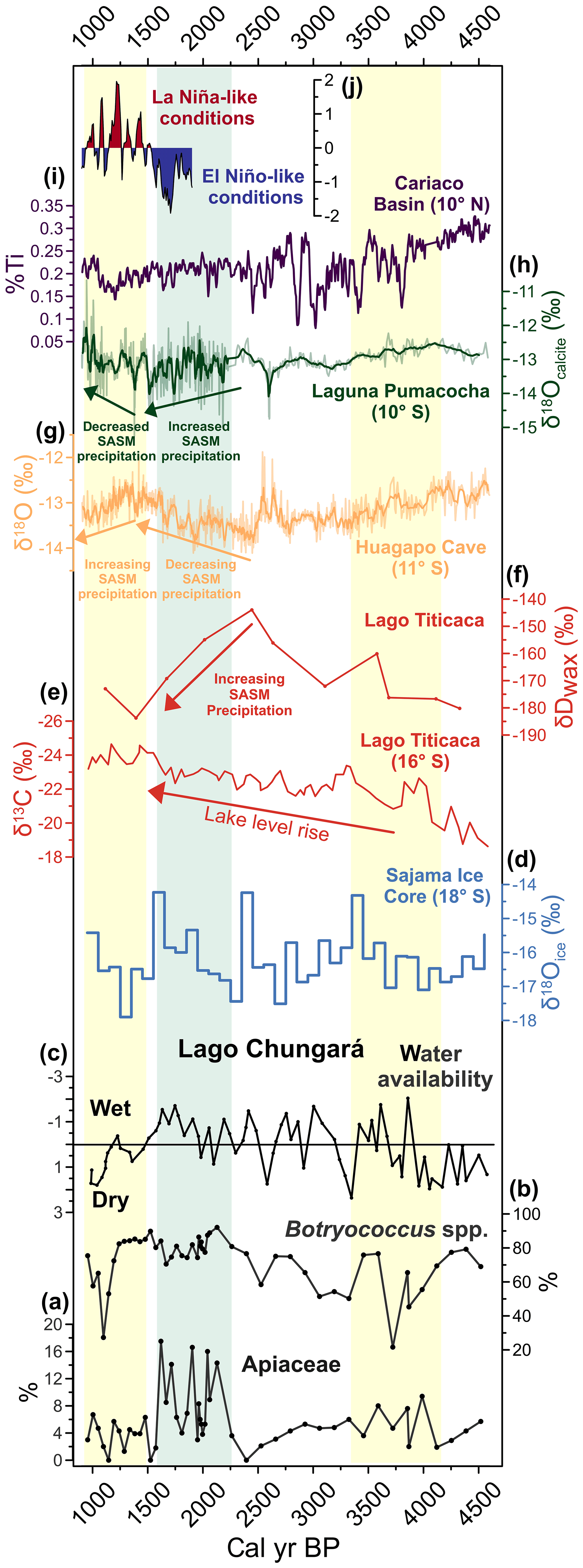
Figure 6Summary plot including key Lago Chungará climate indicators (black curves) and selected paleoclimate records from the tropical Andes and the Pacific Ocean. (a) Apiaceae pollen percentage, (b) Botryococcus spp. percentage, (c) Lago Chungará second eigenvectors (15 %) of a principal component analysis from the geochemical dataset (Giralt et al., 2008), (d) δ18O record of ice water from the Sajama ice core (Thompson et al., 2000), (e) δ13C record from Lago Titicaca (Baker et al., 2005), (f) δD record of terrestrial leaf waxes from Lago Titicaca (Fornace et al., 2014), (g) δ18O record from speleothems inside Huagapo Cave (Kanner et al., 2013), (h) δ18O record of calcite in sediments from Laguna Pumacocha (Bird et al., 2011), (i) % Ti from Cariaco Basin (Haug et al., 2001), and (j) Southern Oscillation Index (SOI) reconstruction from eastern and western tropical pacific records (Yan et al., 2011). Yellow bands indicate dry anomalies, whereas the green band shows the wet anomaly as recorded in Lago Chungará.
5.3 Drivers and teleconnections
Based on the modern pollen–climate relationships in the Chungará area discussed in Sect. 5.1, we interpret the aforementioned precipitation anomalies as responding to long-term variations in the mean strength of the SASM, with a weakened SASM between 4100–3300 and 1600–1000 cal yr BP and a strengthening between 2400 and 1600 cal yr BP. To identify potential drivers of past SASM-related precipitation anomalies at Lago Chungará, Fig. 6 shows two of our pollen–climate indicators (Fig. 6a–b) and a previously published hydrological reconstruction from Lago Chungará (Giralt et al., 2008) (Fig. 6c), along with a selection of paleoclimate reconstructions from the Altiplano, the tropical Andes, and the tropical Pacific region (10 ∘ N–18∘ S). It is evident from this composite plot that our inferred dry conditions for the 4100–3400 cal yr BP interval seem at odds with the previous reconstruction of water availability based on geochemical data from Lago Chungará, which exhibits an alternation of dry and humid conditions without a consistent trend during this interval (Fig. 6c). These differences could be explained in light of the dissimilar climate sensitivity of the sediment geochemistry and pollen proxies. Nonetheless, we note that the transition from humid (2400–1600 cal yr BP) to dry conditions (1600–1000 cal yr BP) revealed by our pollen record agrees with similar hydrological changes (Giralt et al., 2008), as well as with a dry event at 1500 cal yr BP detected in the Lago Chungará diatom profile (Bao et al., 2015; not shown). We will therefore perform hemispheric comparisons to identify the forcing mechanism of these two latter climate anomalies.
The centennial wet–dry anomalies experienced in Lago Chungará between 2400 and 1000 cal yr BP can be reconciled with some hydrological records from the western Andes slopes and adjacent Atacama Desert. For instance, pollen preserved in fossil rodent middens from Salar del Huasco (20∘ S) reveal the onset of a humid period at around 2100 cal yr BP (Maldonado and Uribe, 2012), while radiocarbon dating of organic deposits at Quebrada Maní (21∘ S) indicates a moist interval between 2500 and 2000 cal yr BP (Gayo et al., 2012). Humid conditions are recorded as far south as 23∘ S, as indicated by an increase in terrestrial plant productivity around 2000 cal yr BP inferred from macrofossil assemblages in rodent middens (Latorre et al., 2002). Further north, the Chungará climate anomalies are partially correlated with precipitation records from Lago Titicaca (15∘ S) in the central Altiplano. A δ13C record from this lake shows a long-term increase in lake levels over the last 4500 years without any appreciable centennial-scale excursion comparable to that observed at Lago Chungará (Baker et al., 2005) (Fig. 6e). In fact, the highest lake levels are recorded between 1400 and 1000 cal yr BP, coetaneous with the inferred low stands at Lago Chungará. However, we note that the steady rise in Lago Titicaca water levels halts at ∼1400 cal yr BP, suggesting an interruption in this long-term trend. Notably, a more recent precipitation reconstruction based on δ deuterium (δD) values of terrestrial leaf waxes from the same lake suggests a marked strengthening of the SASM inferred from rapid isotopic depletion between 2500 and 1400 cal yr BP (Fornace et al., 2014) (Fig. 6f). Thus, the Titicaca records reveal an overall intensification of the SASM and sustained rise in lake levels until 1400 cal yr BP, with stable lake stands after that time.
The SASM anomalies reconstructed from Lago Chungará do not correspond to the δ18O changes in the Sajama ice record, just 35 km northeast of Lago Chungará (18∘ S; Thompson et al., 1998). This isotopic record exhibits a sustained trend towards isotopically enriched values between 2500 and 1600 cal yr BP (decreased SASM intensity), followed by an abrupt depletion between 1600 and 1200 cal yr BP (increased SASM intensity) (Fig. 6d). Similarly, high-resolution δ18O records from the tropical Andes such as Lago Junín and Huagapo Cave (11∘ S) also exhibit enrichment between 2500 and 1500 cal yr BP, in disagreement with Lago Chungará (Seltzer et al., 2000; Kanner et al., 2013) (Fig. 6g). The isotopic record from Laguna Pumacocha (10∘ S) reveals a slight depletion (increased SASM precipitation) between 2500 and 1500 cal yr BP, followed by an overall enrichment (decrease) between 1500 and 1000 cal yr BP, more closely aligned with the Lago Chungará trends (Fig. 6h). Further north, the record of metal concentrations from the Cariaco Basin off the Venezuelan coast (10 ∘ N; Haug et al., 2001) does not show any noticeable change between 2300 and 1100 cal yr BP (Fig. 6i), suggesting that the SASM changes recorded at Chungará were largely decoupled from north–south shifts of the Intertropical Convergence Zone.
In sum, correlations with paleoclimate reconstructions from the Atacama Desert and the Altiplano indicate that the centennial-scale precipitation anomalies detected at Lago Chungará were regional paleoclimate events caused by the strengthening and weakening of the SASM in those regions. On the other hand, the timing, direction, and magnitude of our reconstructed anomalies are considerably less replicated in SASM reconstructions from the tropical Andes and further north. Such discrepancies could emerge from different climate sensitivities, chronological uncertainties, and/or distinct sources of SASM precipitation between northern and southern sites. Comparisons between isotopic values in proxy records and modern rainfall time series, as well as model outputs, suggest that the δ18O signal from ice, autogenic lacustrine calcite, and speleothem carbonates from the tropical Andes reflects primary changes in the isotopic composition of precipitation associated with the intensity of the SASM; that is to say, these proxies are sensitive recorders of past monsoonal precipitation (Vuille and Werner, 2005; Hurley et al., 2016; Bird et al., 2011a). In addition, most of these reconstructions are supported by accurately U ∕ Th and 14C chronologies, and therefore chronological uncertainties are also unlikely. Hence, the discrepancies between reconstructions from the tropical Andes and the Altiplano–Atacama region probably resulted from the influence of different drivers of the SASM.
A 2000-year record of ENSO-like changes based on several published precipitation records in the western and eastern tropical Pacific Ocean (Yan et al., 2011) offers an insightful comparison with our Chungará precipitation anomalies. These Pacific records depict predominantly El Niño-like conditions between 2000 and 1500 cal yr BP, followed by La Niña-like conditions between 1500 and 950 cal yr BP (Yan et al., 2011) (Fig. 6j). Hence, increased SASM-derived summer precipitation at Lago Chungará occurred predominately under El Niño-like conditions, whereas decreased SASM precipitation occurred predominately under La Niña-like conditions. In fact, the percentage of sands from El Junco Lake in the Galápagos Island (1∘ S; Conroy et al., 2008) (Fig. 1), one of the proxies presented in the Yan et al. (2011) ENSO reconstruction, extends the interval of El Niño-like conditions back to 2200 cal yr BP, while variations in the concentration and isotopic signal of the algae Botryococcus spp. from the same lake suggest that strong and frequent El Niño events extended back to 3000 cal yr BP (Zhang et al., 2014), encompassing the humid anomaly observed at Lago Chungará completely. In addition, enhanced El Niño conditions between 2600 and 2000 cal yr BP have recently been reconstructed from δ13C records in subtropical eastern Australia (27∘ S) (Barr et al., 2019). These multiple correlations indicate that the modern ENSO–precipitation relationship in the Altiplano (i.e. high precipitation during La Niña conditions and vice versa) observed at inter-annual timescales in the instrumental records (Vuille, 1999), as well as at decadal timescales in tree ring chronologies (Morales et al., 2012), fails to explain the centennial-scale anomalies detected at Lago Chungará.
Thus, what climatic mechanisms drove the observed SASM changes at Chungará? We note that a latitudinal gradient in precipitation anomalies over the Altiplano and tropical Andes has already been pointed out in a recent speleothem δ18O record from the Chiflonkhakha cave system on the eastern slopes of the Andes (18∘ S; Apaéstegui et al., 2018) (Fig. 1). This study shows that overall humid conditions occurred between 1050 and 850 cal yr BP, an anomaly that is progressively recorded with less intensity towards the north until it is no longer detected at sites north of 10∘ S. This latitudinal gradient can be explained if the source of precipitation is not tropical in origin but originated in southeastern South America and the South Atlantic Ocean (>20∘ S). The lack of correspondence between Lago Chungará and tropical records of past ITCZ and ENSO behaviour, summed to the latitudinal gradient in centennial-scale SASM responses, is consistent with this explanation, suggesting an extratropical source of SASM precipitation that could explain the wet–dry anomalies detected in Lago Chungará and other sites in the Atacama Desert and the Altiplano between 2400 and 1000 cal yr BP. This interpretation is also consistent with the modes of modern Altiplano precipitation presented by Vuille and Keimin (2004), which demonstrated that changes in the source of precipitation can generate distinctive patterns of spatial rainfall variability across the Altiplano. Whilst present-day inter-annual precipitation in the northern Altiplano (<18∘ S) and the tropical Andes is largely tropical in origin and linked to modern shifts of the ITCZ and ENSO, convective activity in the southern Altiplano (>18∘ S) is strongly correlated with humidity fluctuations in the Gran Chaco basin (25∘ S), southeast of Chungará (Garreaud et al., 2009). Interestingly, a sea surface temperature (SST) reconstruction from core GeoB6211-1/2 at the South Atlantic coast (32∘ S) shows increased SST between 2300 and 1500 cal yr BP and decreased SST between 1500 and 1100 cal yr BP (Chiessi et al., 2014). In this region, positive SST anomalies are linked to an intensification and northward migration of the South Atlantic Convergence Zone (SACZ), a band of convective activity that connects the South Atlantic to the core of the South American continent (Garreaud et al., 2009) (Fig. 2b). The SACZ is a major contributor to the SASM in southeastern South America, as evidenced in modern climatological studies (Chaves and Nobre, 2004). In fact, a strong connection between the SACZ and the SASM has been suggested in a precipitation reconstruction based on speleothem δ18O variations in Lapa Grande Cave in southeastern Brazil (14∘ S; Stríkis et al., 2011) (Fig. 1), which features rapid short-lived increases in precipitation at 2300, 2200, and 1900 cal yr BP, in correspondence with the Lago Chungará positive precipitation anomaly. A scenario with higher South Atlantic SST, outside the tropical belt, could have prevented a reduction of the tropical Atlantic interhemispheric SST gradient, which otherwise should have led to a southward shift of the ITCZ (Chiessi et al., 2009; Carton et al., 1996). A strengthened SACZ and the associated convective activity without significant variations in the mean position of the ITCZ therefore represents a possibility that needs to be tested by future works. In summary, based on all the evidence we hypothesize that the precipitation anomalies observed at Lago Chungará and the southern part of the Altiplano are explained by centennial-scale changes in the humidity levels to the southeast of South America and the South Atlantic Ocean, which could have been decoupled from changes in the tropics at certain intervals in the past.
Our late Holocene pollen-based reconstruction from Lago Chungará reveals that significant changes in the altitudinal distribution of vegetation communities, terrestrial plant productivity, and lake levels occurred in the Altiplano. We interpret these changes as resulting from anomalies in precipitation associated with changes in the mean strength of the SASM at centennial timescales. In particular, we detected dry conditions suggestive of a weakening of the SASM between 4100–3300 and 1600–1000 cal yr BP and a conspicuous humid interval reflecting a strengthening of the SASM between 2400 and 1600 cal yr BP. Comparisons with multiple paleoclimate records from the Altiplano and the tropical Andes show spatially coherent changes in SASM intensity at centennial timescales, which were largely decoupled from records of the past positions of ITCZ and ENSO polarity. Hence, the close relationship between ENSO and precipitation in the Altiplano documented at inter-annual and decadal timescales cannot be extended to the centennial or multi-centennial domain. We further note a clear south–north gradient in the magnitude of precipitation responses, with southern records in the Altiplano and the Atacama Desert responding more markedly than northern sites in the tropical Andes. All this evidence is consistent with an extratropical source of moisture driving centennial-scale changes in SASM precipitation in the former regions, which is supported by modern climatological studies (Vuille and Keimig, 2004) and interpretations made from recent reconstructions (Apaéstegui et al., 2018). Finally, our results highlight (1) the lack of correspondence between past changes in the strength of the SASM at centennial timescales and climate components sourced in the tropics, which are the dominant drivers of the modern SASM, and (2) a strong teleconnection between the southern Altiplano and the extratropics during the most recent millennia. Hence, caution is required in assuming that the tropical drivers of precipitation in the Altiplano represent the exclusive forcings from which future conditions should be expected.
All data used to interpret the Lago Chungará record are provided in the article. All the information from other records is given in their respective reference in the main text. The pollen data from Lago Chungará will be freely available on the Neotoma paleoecological database (https://www.neotomadb.org/, last access: 11 September 2019) once this article is accepted for publication. Additional data regarding this investigation can be requested from the corresponding author or from Ignacio A. Jara (ignacio.jara@ceaza.cl).
The supplement related to this article is available online at: https://doi.org/10.5194/cp-15-1845-2019-supplement.
AS, AH, SG, RB, BVG, and AM carried out the field campaign and obtained the sediments. LG analysed the pollen samples. IAJ designed the study and analysed and interpreted the data. IAJ wrote the paper and prepared all the figures with the assistance of AM, AS, AH, SG, RB, and BVG.
The authors declare that they have no conflict of interest.
This investigation was funded by Fondecyt grant 1181829 and International Cooperation Grant PI20150081. The Spanish Ministry of Science and Innovation funded this research through the projects ANDESTER (BTE2001-3225), Complementary Action (BTE2001-5257-E), LAVOLTER (CGL2004- 00683/BTE), GEOBILA (CGL2007-60932/BTE), and CONSOLIDER Ingenio 2010 GRACCIE (CSD2007-00067). In addition, we acknowledge funding from the Spanish government through the MEDLANT project. BV-G is grateful for the support of project CGL2016-76215-R/BTE. IAJ would like to thank David López from CEAZA for his assistance in the drawing of Figs. 1–2 and Andrew BH Rees from Victoria University of Wellington, New Zealand, for his aid with the multivariate statistics. IAJ was supported by Fondecyt postdoctoral grant no. 3190181. AH was supported by a Beatriu de Pinós–Marie Curie COFUND contract within the framework of the FLOODES2k (2016 BP 00023) project.
This research has been supported by the Gobierno Español (MEDLANT Project).
This paper was edited by Hans Linderholm and reviewed by four anonymous referees.
Aceituno, P. and Montecinos, A.: Circulation anomalies associated with dry and wet periods in the South American Altiplano, Proc. Fourth Int. Conf. on Southern Hemisphere Meteorology, 330–331, 1993.
Allmendinger, R. W., Jordan, T. E., Kay, S. M., and Isacks, B. L.: The evolution of the Altiplano-Puna plateau of the Central Andes, Annu. Rev. Earth Pl. Sc., 25, 139–174, 1997.
Apaéstegui, J., Cruz, F. W., Vuille, M., Fohlmeister, J., Espinoza, J. C., Sifeddine, A., Strikis, N., Guyot, J. L., Ventura, R., and Cheng, H.: Precipitation changes over the eastern Bolivian Andes inferred from speleothem (δ18O) records for the last 1400 years, Earth Planet. Sc. Lett., 494, 124–134, 2018.
Arroyo, M. T. K., Squeo, F. A., Armesto, J. J., and Villagran, C.: Effects of aridity on plant diversity in the northern Chilean Andes: Results of a natural experiment, Ann. Mo. Bot. Gard., 75, 55–78, 1988.
Baker, P. A., Fritz, S. C., Garland, J., and Ekdahl, E.: Holocene hydrologic variation at Lake Titicaca, Bolivia/Peru, and its relationship to North Atlantic climate variation, J. Quaternary Sci., 20, 655–662, 2005.
Bao, R., Hernández, A., Sáez, A., Giralt, S., Prego, R., Pueyo, J., Moreno, A., and Valero-Garcés, B. L.: Climatic and lacustrine morphometric controls of diatom paleoproductivity in a tropical Andean lake, Quaternary Sci. Rev., 129, 96–110, 2015.
Barnes, J. and Ehlers, T.: End member models for Andean Plateau uplift, Earth-Sci. Rev., 97, 105–132, 2009.
Barr, C., Tibby, J., Leng, M., Tyler, J., Henderson, A., Overpeck, J., Simpson, G., Cole, J., Phipps, S., and Marshall, J.: Holocene el Niño–southern Oscillation variability reflected in subtropical Australian precipitation, Sci. Rep., 9, 1627, https://doi.org/10.1038/s41598-019-38626-3, 2019.
Bird, B. W., Abbott, M. B., Rodbell, D. T., and Vuille, M.: Holocene tropical South American hydroclimate revealed from a decadally resolved lake sediment δ18O record, Earth Planet. Sc. Lett., 310, 192–202, https://doi.org/10.1016/j.epsl.2011.08.040, 2011a.
Bird, B. W., Abbott, M. B., Vuille, M., Rodbell, D. T., Stansell, N. D., and Rosenmeier, M. F.: A 2300-year-long annually resolved record of the South American summer monsoon from the Peruvian Andes, P. Natl. Acad. Sci. USA, 108, 8583–8588, 2011b.
Brush, S. B.: The natural and human environment of the central Andes, Mt. Res. Dev., 2, 19–38, 1982.
Bustamante, M., Cruz, F., Vuille, M., Apaéstegui, J., Strikis, N., Panizo, G., Novello, F., Deininger, M., Sifeddine, A., and Cheng, H.: Holocene changes in monsoon precipitation in the Andes of NE Peru based on δ18O speleothem records, Quaternary Sci. Rev., 146, 274–287, 2016.
Carton, J. A., Cao, X., Giese, B. S., and Da Silva, A. M.: Decadal and interannual SST variability in the tropical Atlantic Ocean, J. Phys. Ocean., 26, 1165–1175, 1996.
Chaves, R. R. and Nobre, P.: Interactions between sea surface temperature over the South Atlantic Ocean and the South Atlantic Convergence Zone, Geophys. Res. Lett., 31, https://doi.org/10.1029/2003GL018647, 2004.
Chiessi, C. M., Mulitza, S., Pätzold, J., Wefer, G., and Marengo, J. A.: Possible impact of the Atlantic Multidecadal Oscillation on the South American summer monsoon, Geophys. Res. Lett., 36, https://doi.org/10.1029/2009GL039914, 2009.
Chiessi, C. M., Mulitza, S., Groeneveld, J., Silva, J. B., Campos, M. C., and Gurgel, M. H.: Variability of the Brazil Current during the late Holocene, Palaeogeogr. Palaeocl., 415, 28–36, 2014.
Conroy, J. L., Overpeck, J. T., Cole, J. E., Shanahan, T. M., and Steinitz-Kannan, M.: Holocene changes in eastern tropical Pacific climate inferred from a Galápagos lake sediment record, Quaternary Sci. Rev., 27, 1166–1180, 2008.
De Porras, M. E., Maldonado, A., De Pol-Holz, R., Latorre, C., and Betancourt, J. L.: Late Quaternary environmental dynamics in the Atacama Desert reconstructed from rodent midden pollen records, J. Quaternary. Sci., 32, 665–684, doi:10.1002/jqs.2980, 2017.
De Silva, S.: Altiplano-Puna volcanic complex of the central Andes, Geology, 17, 1102–1106, 1989.
Deser, C., Knutti, R., Solomon, S., and Phillips, A. S.: Communication of the role of natural variability in future North American climate, Nat. Clim. Change, 2, 775–779, 2012.
Faegri, K. and Iversen, J.: Textbook of Pollen Analysis, four Edn., John Wiley & Sons, New York, 328 pp., 1989.
Fick, S. E. and Hijmans, R. J.: WorldClim 2: new 1-km spatial resolution climate surfaces for global land areas, Int. J. Clim., 37, 4302–4315, 2017.
Fornace, K. L., Hughen, K. A., Shanahan, T. M., Fritz, S. C., Baker, P. A., and Sylva, S. P.: A 60 000-year record of hydrologic variability in the Central Andes from the hydrogen isotopic composition of leaf waxes in Lake Titicaca sediments, Earth Planet. Sc. Lett., 408, 263–271, 2014.
Garreaud, and Aceituno, P.: Interannual rainfall variability over the South American Altiplano, J. Climate, 14, 2779–2789, 2001.
Garreaud, R., Vuille, M., and Clement, A. C.: The climate of the Altiplano: observed current conditions and mechanisms of past changes, Palaeogeogr. Palaeocl., 194, 5–22, 2003.
Garreaud, R.: The Andes climate and weather, Adv. Geosci., 22, 3–11, 2009.
Garreaud, R. D., Vuille, M., Compagnucci, R., and Marengo, J.: Present-day South American climate, Palaeogeogr. Palaeocl., 281, 180–195, 2009.
Garzione, C. N., Molnar, P., Libarkin, J. C., and MacFadden, B. J.: Rapid late Miocene rise of the Bolivian Altiplano: Evidence for removal of mantle lithosphere, Earth Planet. Sc. Lett., 241, 543–556, 2006.
Garzione, C. N., McQuarrie, N., Perez, N. D., Ehlers, T. A., Beck, S. L., Kar, N., Eichelberger, N., Chapman, A. D., Ward, K. M., and Ducea, M. N.: Tectonic evolution of the Central Andean plateau and implications for the growth of plateaus, Annu. Rev. Earth Pl. Sc., 45, 529–559, 2017.
Gaupp, R., Kött, A., and Wörner, G.: Palaeoclimatic implications of Mio–Pliocene sedimentation in the high-altitude intra-arc Lauca Basin of northern Chile, Palaeogeogr. Palaeocl., 151, 79–100, 1999.
Gayo, E. M., Latorre, C., Santoro, C. M., Maldonado, A., and De Pol-Holz, R.: Hydroclimate variability in the low-elevation Atacama Desert over the last 2500 yr, Clim. Past, 8, 287–306, https://doi.org/10.5194/cp-8-287-2012, 2012.
Giralt, S., Moreno, A., Bao, R., Sáez, A., Prego, R., Valero-Garcés, B. L., Pueyo, J. J., González-Sampériz, P., and Taberner, C.: A statistical approach to disentangle environmental forcings in a lacustrine record: the Lago Chungará case (Chilean Altiplano), J. Paleolimnol., 40, 195–215, 2008.
Gonfiantini, R., Roche, M.-A., Olivry, J.-C., Fontes, J.-C., and Zuppi, G. M.: The altitude effect on the isotopic composition of tropical rains, Chem. Geol., 181, 147–167, 2001.
Graf, K.: Discussion of palynological methods and paleoclimatical interpretations in northern Chile and the whole Andes, Rev. Chil. Hist. Nat., 67, 405–415, 1994.
Grimm, E. C.: CONISS: a FORTRAN 77 program for stratigraphically constrained cluster analysis by the method of incremental sum of squares, Comput. Geosci., 13, 13–35, 1987.
Grosjean, M., Van Leeuwen, J., Van Der Knaap, W., Geyh, M., Ammann, B., Tanner, W., Messerli, B., Núñez, L., Valero-Garcés, B., and Veit, H.: A 22,000 14 ∘C year BP sediment and pollen record of climate change from Laguna Miscanti (23∘ S), northern Chile, Global Planet. Change, 28, 35–51, 2001.
Haug, G. H., Hughen, K. A., Sigman, D. M., Peterson, L. C., and Röhl, U.: Southward migration of the intertropical convergence zone through the Holocene, Science, 293, 1304–1308, 2001.
Hernandez, A., Bao, R., Giralt, S., Leng, M. J., Barker, P. A., Saez, A., Pueyo, J. J., Moreno, A., Valero-Garcés, B. L., and Sloane, H. J.: The palaeohydrological evolution of Lago Chungará (Andean Altiplano, northern Chile) during the Lateglacial and early Holocene using oxygen isotopes in diatom silica, J. Quaternary Sci., 23, 351–363, 2008.
Hernández, A., Giralt, S., Bao, R., Sáez, A., Leng, M. J., and Barker, P. A.: ENSO and solar activity signals from oxygen isotopes in diatom silica during late glacial-Holocene transition in Central Andes (18∘ S), J. Paleolimnol., 44, 413–429, 2010.
Hernández, A., Bao, R., Giralt, S., Barker, P. A., Leng, M. J., Sloane, H. J., and Sáez, A.: Biogeochemical processes controlling oxygen and carbon isotopes of diatom silica in Late Glacial to Holocene lacustrine rhythmites, Palaeogeogr. Palaeocl., 299, 413–425, 2011.
Hernández, A., Bao, R., Giralt, S., Sáez, A., Leng, M. J., Barker, P. A., Kendrick, C. P., and Sloane, H. J.: Climate, catchment runoff and limnological drivers of carbon and oxygen isotope composition of diatom frustules from the central Andean Altiplano during the Lateglacial and Early Holocene, Quaternary Sci. Rev., 66, 64–73, 2013.
Herrera, C., Pueyo, J. J., Sáez, A., and Valero-Garcés, B. L.: Relación de aguas superficiales y subterráneas en el área del lago Chungará y lagunas de Cotacotani, norte de Chile: un estudio isotópico, Revista geológica de Chile, 33, 299–325, 2006.
Hora, J. M., Singer, B. S., and Wörner, G.: Volcano evolution and eruptive flux on the thick crust of the Andean Central Volcanic Zone: 40Ar/39Ar constraints from Volcán Parinacota, Chile, Geol. Soc. Am. Bull., 119, 343–362, 2007.
Hurley, J., Vuille, M., and Hardy, D.: Forward modeling of δ18O in Andean ice cores, Geophys. Res. Lett., 43, 8178–8188, 2016.
Isacks, B. L.: Uplift of the central Andean plateau and bending of the Bolivian orocline, J. Geophys. Res.-Sol. Ea., 93, 3211–3231, 1988.
Jankovská, V. and Komárek, J.: Indicative value ofPediastrum and other coccal green algae in palaeoecology, Folia Geobot., 35, 59–82, 2000.
Jicha, B. R., Laabs, B. J., Hora, J. M., Singer, B. S., and Caffee, M. W.: Early Holocene collapse of Volcán Parinacota, central Andes, Chile: Volcanological and paleohydrological consequences, Bulletin, 127, 1681–1688, 2015.
Jomelli, V., Khodri, M., Favier, V., Brunstein, D., Ledru, M.-P., Wagnon, P., Blard, P.-H., Sicart, J.-E., Braucher, R., and Grancher, D.: Irregular tropical glacier retreat over the Holocene epoch driven by progressive warming, Nature, 474, 196–199, 2011.
Kanner, L. C., Burns, S. J., Cheng, H., Edwards, R. L., and Vuille, M.: High-resolution variability of the South American summer monsoon over the last seven millennia: insights from a speleothem record from the central Peruvian Andes, Quaternary Sci. Rev., 75, 1–10, 2013.
Knüsel, S., Brütsch, S., Henderson, K., Palmer, A., and Schwikowski, M.: ENSO signals of the twentieth century in an ice core from Nevado Illimani, Bolivia, J. Geophys. Res.-Atmos., 110, https://doi.org/10.1029/2004JD005420, 2005.
Kull, C., Grosjean, M., and Veit, H.: Modeling modern and Late Pleistocene glacio-climatological conditions in the north Chilean Andes (29–30), Clim. Change, 52, 359–381, 2002.
Latorre, C., Betancourt, J. L., Rylander, K. A., and Quade, J.: Vegetation invasions into absolute desert: A 45 000 yr rodent midden record from the Calama–Salar de Atacama basins, northern Chile (lat 22∘ –24∘ S), Geol. Soc. Am. Bull., 114, 349–366, 2002.
Latorre, C., Betancourt, J. L., and Arroyo, M. T.: Late Quaternary vegetation and climate history of a perennial river canyon in the Río Salado basin (22∘ S) of Northern Chile, Quaternary Res., 65, 450–466, 2006.
Loisel, J., MacDonald, G. M., and Thomson, M. J.: Little Ice Age climatic erraticism as an analogue for future enhanced hydroclimatic variability across the American Southwest, PloS One, 12, e0186282, https://doi.org/10.1371/journal.pone.0186282, 2017.
Maldonado, A., Betancourt, J. L., Latorre, C., and Villagran, C.: Pollen analyses from a 50,000-yr rodent midden series in the southern Atacama Desert (25∘300′ S), J. Quaternary Sci., 20, 493–507, 2005.
Maldonado, A. and Uribe, M.: Paleoambientes y ocupaciones humanas en tarapacá durante el período formativo y comienzos del intermedio tardío, XIX Congreso Nacional de Arqueología Chilena, Arica, Chile, 8 pp., 2012.
Marcott, S. A., Shakun, J. D., Clark, P. U., and Mix, A. C.: A reconstruction of regional and global temperature for the past 11 300 years, Science, 339, 1198–1201, 2013.
Morales, M. S., Christie, D. A., Villalba, R., Argollo, J., Pacajes, J., Silva, J. S., Alvarez, C. A., Llancabure, J. C., and Soliz Gamboa, C. C.: Precipitation changes in the South American Altiplano since 1300 AD reconstructed by tree-rings, Clim. Past, 8, 653–666, https://doi.org/10.5194/cp-8-653-2012, 2012.
Moreno, A., Giralt, S., Valero-Garcés, B., Sáez, A., Bao, R., Prego, R., Pueyo, J., González-Sampériz, P., and Taberner, C.: A 14 kyr record of the tropical Andes: The Lago Chungará sequence (18∘ S, northern Chilean Altiplano), Quaternary Int., 161, 4–21, 2007.
Mühlhauser, H., Hrepic, N., Mladinic, P., Montecino, V., and Cabrera, S.: Water quality and limnological features of a high altitude Andean lake, Chungará, in northern Chile, Rev. Chil. Hist. Nat., 68, 341–349, 1995.
Neukom, R., Rohrer, M., Calanca, P., Salzmann, N., Huggel, C., Acuña, D., Christie, D. A., and Morales, M. S.: Facing unprecedented drying of the Central Andes? Precipitation variability over the period AD 1000–2100, Environ. Res. Lett., 10, 084017, https://doi.org/10.1088/1748-9326/10/8/084017, 2015.
Novello, V. F., Vuille, M., Cruz, F. W., Stríkis, N. M., De Paula, M. S., Edwards, R. L., Cheng, H., Karmann, I., Jaqueto, P. F., and Trindade, R. I.: Centennial-scale solar forcing of the South American Monsoon System recorded in stalagmites, Sci. Rep., 6, 24762, https://doi.org/10.1038/srep24762, 2016.
Orellana, L., Altamirano, T., Ortíz, G., Henríquez, G., Espinosa, M., and Poblete, V.: Flora y Vegetación VX Región de Arica y Parinacota, Ciren-Chile, Santiago, 31 pp., 2013.
Pueyo, J. J., Sáez, A., Giralt, S., Valero-Garcés, B. L., Moreno, A., Bao, R., Schwalb, A., Herrera, C., Klosowska, B., and Taberner, C.: Carbonate and organic matter sedimentation and isotopic signatures in Lake Chungará, Chilean Altiplano, during the last 12.3 kyr, Palaeogeogr. Palaeocl., 307, 339–355, 2011.
Rabatel, A., Francou, B., Jomelli, V., Naveau, P., and Grancher, D.: A chronology of the Little Ice Age in the tropical Andes of Bolivia (16∘ S) and its implications for climate reconstruction, Quaternary Res., 70, 198–212, 2008.
Rodrıguez, R., Marticorena, C., Alarcón, D., Baeza, C., Cavieres, L., Finot, V., Fuentes, N., Kiessling, A., Mihoc, M., and Pauchard, A.: Catálogo de las plantas vasculares de Chile, Gayana. Botánica, 75, 1–430, 2018.
Rundel, P. W. and Palma, B.: Preserving the unique puna ecosystems of the Andean altiplano: a descriptive account of Lauca National Park, Chile, Mt. Res. Dev., 20, 262–271, 2000.
Sáez, A., Valero-Garcés, B. L., Moreno, A., Bao, R., Pueyo, J., González-Sampériz, P., Giralt, S., Taberner, C., Herrera, C., and Gibert, R. O.: Lacustrine sedimentation in active volcanic settings: the Late Quaternary depositional evolution of Lake Chungará (northern Chile), Sedimentology, 54, 1191–1222, 2007.
Seltzer, G., Rodbell, D., and Burns, S.: Isotopic evidence for late Quaternary climatic change in tropical South America, Geology, 28, 35–38, 2000.
Stríkis, N. M., Cruz, F. W., Cheng, H., Karmann, I., Edwards, R. L., Vuille, M., Wang, X., de Paula, M. S., Novello, V. F., and Auler, A. S.: Abrupt variations in South American monsoon rainfall during the Holocene based on a speleothem record from central-eastern Brazil, Geology, 39, 1075–1078, 2011.
Sulca, J., Takahashi, K., Espinoza, J. C., Vuille, M., and Lavado-Casimiro, W.: Impacts of different ENSO flavors and tropical Pacific convection variability (ITCZ, SPCZ) on austral summer rainfall in South America, with a focus on Peru, Int. J. Climatol., 38, 420–435, 2018.
Thompson, L. G., Davis, M. E., Mosley-Thompson, E., Sowers, T., Henderson, K. A., Zagorodnov, V. S., Lin, P.-N., Mikhalenko, V. N., Campen, R. K., and Bolzan, J. F.: A 25,000-year tropical climate history from Bolivian ice cores, Science, 282, 1858–1864, 1998.
Valero-Garcés, B., Delgado-Huertas, A., Ratto, N., Navas, A., and Edwards, L.: Paleohydrology of Andean saline lakes from sedimentological and isotopic records, Northwestern Argentina, J. Paleolimnol., 24, 343–359, 2000.
Valero-Garcés, B. L., Delgado-Huertas, A., Navas, A., Edwards, L., Schwalb, A., and Ratto, N.: Patterns of regional hydrological variability in central-southern Altiplano (18–26∘ S) lakes during the last 500 years, Palaeogeogr. Palaeocl., 194, 319–338, 2003.
Villagrán, C., Armesto, J. J., and Kalin Arroyo, M. T.: Vegetation in a high Andean transect between Turi and Cerro León in Northern Chile, Plant. Ecol., 48, 3–16, doi:10.1007/bf00117356, 1981.
Villagrán, C., Kalin Arroyo, M. T., and Marticorena, C.: Efectos de la desertización en la distribución de la flora andina de Chile, Rev. Chil. Hist. Nat., 56, 137–157, 1983.
Vuille, M.: Atmospheric circulation over the Bolivian Altiplano during dry and wet periods and extreme phases of the Southern Oscillation, Int. J. Climatol., 19, 1579–1600, 1999.
Vuille, M. and Keimig, F.: Interannual variability of summertime convective cloudiness and precipitation in the central Andes derived from ISCCP-B3 data, J. Climate, 17, 3334–3348, 2004.
Vuille, M. and Werner, M.: Stable isotopes in precipitation recording South American summer monsoon and ENSO variability: observations and model results, Clim. Dynam., 25, 401–413, 2005.
Vuille, M., Bradley, R. S., and Keimig, F.: Interannual climate variability in the Central Andes and its relation to tropical Pacific and Atlantic forcing, J. Geophys. Res.-Atmos., 105, 12447–12460, doi:10.1029/2000JD900134, 2000.
Vuille, M., Burns, S. J., Taylor, B. L., Cruz, F. W., Bird, B. W., Abbott, M. B., Kanner, L. C., Cheng, H., and Novello, V. F.: A review of the South American monsoon history as recorded in stable isotopic proxies over the past two millennia, Clim. Past, 8, 1309–1321, https://doi.org/10.5194/cp-8-1309-2012, 2012.
Wanner, H., Beer, J., Bütikofer, J., Crowley, T. J., Cubasch, U., Flückiger, J., Goosse, H., Grosjean, M., Joos, F., and Kaplan, J. O.: Mid-to Late Holocene climate change: an overview, Quaternary Sci. Rev., 27, 1791–1828, 2008.
Yan, H., Sun, L., Wang, Y., Huang, W., Qiu, S., and Yang, C.: A record of the Southern Oscillation Index for the past 2000 years from precipitation proxies, Nat. Geosci., 4, 611–614, 2011.
Zhang, Z., Leduc, G., and Sachs, J. P.: El Niño evolution during the Holocene revealed by a biomarker rain gauge in the Galápagos Islands, Earth Planet. Sc. Lett., 404, 420–434, 2014.